Skip to content
No results
  • Home
  • About Tuxtepec and La Chinantla
    • History
    • Touristic Map of Tuxtepec
    • Tourist Map of the Chinantla
  • What To Do
    • Tuxtepec City
      • Architecture
      • Plaza Juárez
      • Plaza La Piragua
      • El Muro (The Dyke)
      • Mercado Central (Central Market)
      • The Pier (El embarcadero)
      • Ruins “El Castillo”
      • Plan of Tuxtepec
      • Casa de la Cultura (Cultural Center)
      • Iguanario
      • Papaloapan River
      • Flor de Piña – A dance performed at the Guelaguetza
      • Corona Factory (Brewery of Corona Beer)
    • Nature & Ecotourism
      • A Thousand Islands (Mil Islas)
      • Spider Monkey Habitat
      • Jungle
      • Cloud Forest
      • Pine Forest
    • Springs & Waterfalls
      • Zuzul
      • Bethania Waterfalls
      • Naranjal Waterfalls
      • Monte Flor
      • San Martin
    • Indigenous communities
      • Soyaltepec Island
      • Temascal (New Soyaltepec or San Miguel Soyaltepec)
      • San Andrés Cerro Quemado
      • San Pedro Ixcatlán
      • Vega Del Sol
      • Cerro Marín
      • Valle Nacional
      • Rancho Grande
      • San Lucas Ojitlán
      • San Felipe Usila
      • Jalapa de Díaz
    • Archaeological Sites
      • Ruins “El Castillo”
      • Ruins of Pueblo Viejo
      • Phe-hispanic city of Mundo Nuevo
    • Dams and Artificial Lakes
      • Dam and lake Miguel Alemán (Temascal)
      • Dam and lake Miguel de la Madrid (Cerro de Oro)
    • Gastronomy
      • Typical Dishes
      • Typical Drinks
      • Fruits of the Region
    • Other cities in the Cuenca del Papaloapan region
      • Loma Bonita
      • Otatitlán and The Black Jesus
      • Tlacotalpan
    • Ruta Chinantla
  • Fiestas
  • Blog
  • English
    • Español
    • English
Tuxtepec Tourism
  • Home
  • About Tuxtepec and La Chinantla
    • History
    • Touristic Map of Tuxtepec
    • Tourist Map of the Chinantla
  • What To Do
    • Tuxtepec City
      • Architecture
      • Plaza Juárez
      • Plaza La Piragua
      • El Muro (The Dyke)
      • Mercado Central (Central Market)
      • The Pier (El embarcadero)
      • Ruins “El Castillo”
      • Plan of Tuxtepec
      • Casa de la Cultura (Cultural Center)
      • Iguanario
      • Papaloapan River
      • Flor de Piña – A dance performed at the Guelaguetza
      • Corona Factory (Brewery of Corona Beer)
    • Nature & Ecotourism
      • A Thousand Islands (Mil Islas)
      • Spider Monkey Habitat
      • Jungle
      • Cloud Forest
      • Pine Forest
    • Springs & Waterfalls
      • Zuzul
      • Bethania Waterfalls
      • Naranjal Waterfalls
      • Monte Flor
      • San Martin
    • Indigenous communities
      • Soyaltepec Island
      • Temascal (New Soyaltepec or San Miguel Soyaltepec)
      • San Andrés Cerro Quemado
      • San Pedro Ixcatlán
      • Vega Del Sol
      • Cerro Marín
      • Valle Nacional
      • Rancho Grande
      • San Lucas Ojitlán
      • San Felipe Usila
      • Jalapa de Díaz
    • Archaeological Sites
      • Ruins “El Castillo”
      • Ruins of Pueblo Viejo
      • Phe-hispanic city of Mundo Nuevo
    • Dams and Artificial Lakes
      • Dam and lake Miguel Alemán (Temascal)
      • Dam and lake Miguel de la Madrid (Cerro de Oro)
    • Gastronomy
      • Typical Dishes
      • Typical Drinks
      • Fruits of the Region
    • Other cities in the Cuenca del Papaloapan region
      • Loma Bonita
      • Otatitlán and The Black Jesus
      • Tlacotalpan
    • Ruta Chinantla
  • Fiestas
  • Blog
  • English
    • Español
    • English
Tuxtepec Tourism

About Tuxtepec and La Chinantla

Tuxtepec_Historia1

History of Tuxtepec and La Chinantla

Tuxtepec comes from the Náhuatl word Tōchtepēc, which means “on the hill of the rabbit”.

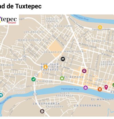
MapaTurísticoCiudadde Tuxtepec copy

Tourist map of the city

Tourist map showing the most important sites of the city.

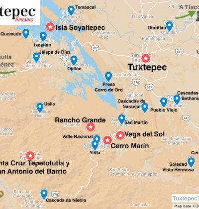
MapaTuristicoTuxtepecAlrededores copy

Tourist map of the Chinantla

Map showing the sites of interest in La Chinantla and some important cities of the Papaloapan region.

Compartir

A simple vista

Datos rápidos

  • 📍Ubicación: Región del Papaloapan, norte de Oaxaca
  • 🌤️Clima: Cálido húmedo todo el año
  • 🗓️Mejor época: Octubre a abril (temporada seca)
  • 🚌Cómo llegar: Terminal ADO, o por carretera desde Oaxaca, Veracruz o CDMX
No te lo pierdas

Top atractivos

  • Mil Islas Mil Islas Naturaleza
  • Museo Casa Verde Tuxtepec Museo Casa Verde Historia y Cultura
  • Jalapa De Díaz Jalapa De Díaz Comunidad Indígena
  • Zuzul Zuzul Manantial Caldo de Piedra Caldo de Piedra Gastronomía regional
Video destacado

5 Cosas que hacer en Tuxtepec

5 Cosas que hacer en Tuxtepec
▶

Ve más videos en nuestro canal →

Mantente cerca

Síguenos

FB IG YT X
¿Planeas tu viaje? Contáctanos
Tuxtepec Turismo
Tuxtepec Turismo

Tu guía para descubrir Tuxtepec y los pueblos originarios de la Chinantla, Oaxaca.

FB IG YT X

Explorar

  • Acerca de Tuxtepec
  • Qué ver y hacer
  • Planea tu visita
  • Festividades
  • Blog
  • Videos

Planea tu viaje

  • Mapa de la ciudad
  • Mapa de la Chinantla
  • Ruta Chinantla
  • 7 razones para visitar

Sitio

  • Acerca de este sitio
  • Política de privacidad
  • Preguntas frecuentes
  • Contacto

Copyright © 2026 Tuxtepec Tourism

- Cualquier tipo de copia o reproducción está estrictamente prohibido -